Ozone
Maps: Color Codes
The timelines consist of
AIRNOW ozone maps of interpolated station monitor data
(8-hour and 1-hour averaged values).
The map value codes for
8-hour maps are:
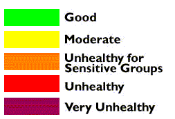
For more information see
AIRNOW maps and related information at: http://www.epa.gov/airnow
Monitor
Station Data: My Color Codes (Year 1999 Only)
Also included are raw data
from monitor stations at the epidemic areas, i.e.,
measurements of air toxics (NO2, O3) as daily median readings
at 15th Ave in College Point (Queens) and Gerard Avenue
(Bronx).
These monitor station
color codes are basically similar to the EPA
8-hour codes. They are designed by me to
express the full range values of 1999, to maximize the
reader's perception of various air toxic levels during 1999.
For example, in 1999, NO1 (example below) fluctuated mostly
between 20 and 69.
| Full Range Values Of
1999 |
| Ozone |
NO1 |
NO2 |
Color |
| 11 |
19 |
20 |
|
| 19 |
29 |
26 |
|
| 25 |
41 |
34 |
|
| 36 |
69 |
43 |
|
| 42 |
106 |
56 |
|