Successful Forecasting
Initial public forecasts began
in mid-summer of 2000. See these early attempts to forecast WNV activity before the method had
been fully developed. See latter
attempts also.
For reference, here is the
summer of 2000, ozone, and WNV activity for NYC. Ozone data
is very precise timewise. West Nile virus activity is loose
for these reasons: Date found for dead birds is somewhat
loose. Date collected for mosquito pools can be loose and
doesn't mean that the mosquito was infected with WNV on the
collection date. Human hospitalizations were usually
preceeded by illness.
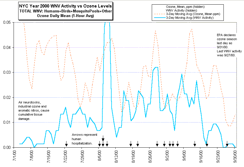
Note that both WNV activity
and ozone levels oscillate at the same frequency. From 7/15/00
onward, every peak and valley in the ozone level line (red)
is reflected in the WNV activity line (blue). 9/12/00 is a
reasonable and minor exception.
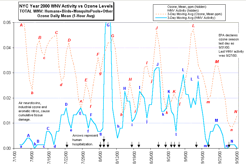
Though initial forecasts have
been a bit clumsy, they have been sucessful re all medium/major
peaks and valleys for WNV activity during the summer of 2000.
I had no station monitor data until 9/27/00, after the ozone/WNV
season, and relied on AirNow maps and weather reports.
Of those outside of medical
orthodoxy, mosquito control agencies, and emergency
management, I am one of the few that can look forward to the
next West Nile virus epidemic.
See below, a comparison of
comments and predictions, extracted from the timeline:
Prediction dates are after the
fact, but before the NYCDOH announcements of test results.
The Fundamentals
West Nile Virus occurs in less
than 8% of massive bird death during the summers of 1999-2000
in the NYC region. Therefore it could not be causative for
the novel, massive bird death. Nevetheless, it occurs
concurrently and therefore is a measure of disease in animals
and humans.
It is my thesis that the
phenomena known as "WNV acivity" correlates with
unprecedented levels of air toxics, which became a novelty as
of 1995 when MTBE levels were increased, and unique refinery
dumping/formulating began in the NYC region. WNV activity is
also concurrent with the decision to begin testing for WNV in
this region as of the summer of 1999 and not to test in other
regions.
Air toxics poisoning became
publically obvious as of the June of 1999 due to record-level
air toxics (not seen since the 1980s) and the overwhelmingly
obvious signs of disease found in the massive bird deaths and
unusual human death.
Since it takes 5 to 30 days
for the DOH to announce bird/mosquito collections and human
hospitalizations, this theory of toxic causation can forecast
the official announcements by several days, being accurate
within hours of air toxic indicators. It appears that the DOH
announcements usually take 5 to 12 days.
Forecast Method
Goal: To forecast increased
WNV activity (bird death, WNV-positives, hospitalization,
illness, WNV-positive mosquito pool collections).
Note that ozone and other air
toxics are marginal in their effect, and take a days to
accumulate tissue damage, to bring a bird or human to a
critical threshold where disease is imminent. Disease events
occur during sustained exposure and immediately after high
spikes.
It is assumed that industrial
pollutants, auto traffic, MTBE, and/or air traffic are
present in the epidemic area.
1) Wait. The haze season (ozone)
begins in May. The forecaster should wait for the first
regular reports of dead bird reports to occur, usually in
late June or July. This is the signal that accumulated tissue
damage has reached a threshold and epicenters are defined.
2) Observe the indicators at
the epicenters.
| Indicators of Increased
WNV activity |
| Reliability |
Indicator |
Comment |
| First |
Personal observations of haze (site and
smell). |
Necessary, because AirNow maps can be
grossly revised for unpublicized reasons and they are
wide-focus, interpolated views of large areas. AirNow
maps do not include overnight readings. Weather
stations may not suffice either, as they may not be
near enough to the epicenter, or fog mistaken for
haze, or fog concealing or incorporating haze. |
| Second |
EPA air monitor station data of epidemic
area. |
Very clear and obvious. These are often
already located at the disease epicenters. Their very
existence is indictive of air emission dangers.
Unfortunately, the printed reports may contain large
drop-outs of data due to maintenance or faulty
equipment. |
| Third |
Weather Observations of haze. |
These often show haze when AirNow maps
fail. A haze index formula with timeline are provided. |
| Fourth |
AirNow map indicating ozone in an
epidemic area. |
Very dramatic colored views of
interpolated ozone levels in large areas.
Unfortunately, lacking in resolution and subject to
gross downward revisions. |
| Fifth |
High temperature in epidemic area. |
Air Toxics are more present at ground
level during high temperatures. Convection effect is
less effective in pushing stack emissions into upper
atmosphere. Photochemical effect, necessary for the
generation of smog is more effective during hot and
sunny days. |
If all is
working, then these indicators should act concurrently.
Forecasting a Lull
If all these indicators are
low then a lull in WNV activity is forecasted, though a
faulty indicator, or indicator undergoing maintence, or other
lack of data, can defeat a forecasted lull. Sometimes air
emissions are not shown, or don't show up because they are
intense but local, not affecting station monitors. Sometimes,
the data is revised by the EPA/DEC for unpublicized reasons.